Road Safety Initiative - SAFE
1.Introduction
Safety Application for Field Entities (SAFE) is a tactical solution that is implemented as part of a broader ICT initiative to Road Safety. SAFE is useful in handling post-accident related events like, authenticated Data Collection about the accident, communicating with Command Control Center, and coordinating the different agencies involved in post-accident process. SAFE captures data and photographs which can be shared in real-time with trauma centers, police stations and other patrol vehicles on a need basis. In addition, it can proactively create SMS based alerts to initiate action for pre-specified recipients.
Post-accident events would include handling medical emergencies, providing short-term and long-term treatment (physical and psychological), authenticated data collection for coordination and follow-up, facilitating financial stress (including insurance) as well as clearing of the roads.
SAFE is part of the first-responder tools that will enable handling post-accident events during the golden-hour.
2.0 SAFE Features
SAFE is Android based mobile solution (Accident Information System) that is installed on the mobile device that the first respondents carry. Once the first responder reaches the scene, SAFE is useful in collecting basic data about the Accident, take pictures of the Accident scene and record other information useful in follow up. This data is then uploaded to server that is instantly available to the Command Control Center. The Command Control Center will be able to act quickly based on the location and the severity of the Accident to take additional follow up measures to help the ground staff at the Accident scene.
The mobile device and SAFE application can also act as a communication channel in facilitating coordination and communication between various agencies involved in Road Safety process.
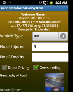
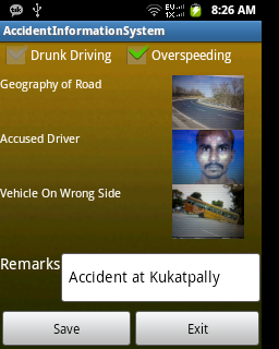
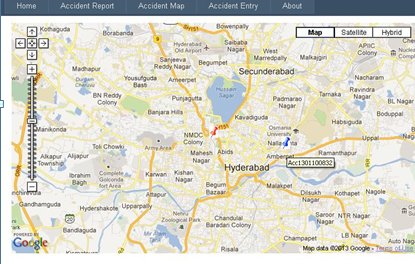
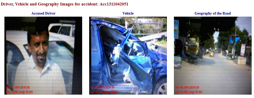
When the information is uploaded to the server, the information is viewed online on Map using the Accident Location's Latitude and Longitude coordinates, and the information such as the data and photographs are also available online for analysis by the Command Control Center. The photographs are watermarked with date-time and latitude and longitude for authenticity.
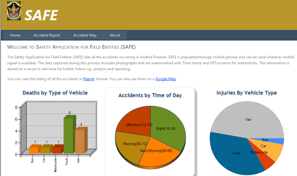
SAFE not only collects and collates information for short-term (Tactical) objective, but can also be useful in collaboration with VATS to analyze the data and enable long-term measures to Road Safety.
3.0 Information Dissemination and SAFE - Mobile Client and Server
The different stake-holders that can benefit from the information collected and collated by SAFE are:
- Police Stations on the highways - The police station is the main node for providing enforcement and primary coordination for any relief action for accidents. The first responder from the Police Station can have the SAFE Mobile Client installed on a mobile device that can be carried by him/her to the accident site. Other information needs of the Police stations that can be served through SAFE are:
- Immediate notification of accidents
- Communication support with other related departments in case of accidents
- Patrol Vehicles - While the patrol vehicles are primarily deployed to deter motorists from incorrect road behavior and facilitate enforcement, these vehicles could also be one of the first ones to arrive at any accident site. The mobile device in the patrol vehicles will have the SAFE Mobile Client installed for use when the patrol vehicle is responding to an accident case. Other information for Patrol Vehicles that will be served through SAFE is:
- Immediate information (including location) of accidents
- Communication with police stations, other patrol / interceptor vehicles and trauma centers
- Interceptor Vehicles - Interceptor vehicles are better equipped to facilitate enforcement, including chasing errant drivers if needed. Other than sophisticated equipment like radar guns, cameras and breath-analyzers, these vehicles would also need to be prepared for dealing with any accidents they come across. Their needs in this context would thus be similar to those of patrol vehicles. The mobile device in the interceptor vehicles will have the SAFE Mobile Client installed for use when the patrol vehicle is responding to an accident case. Other information for Interceptor Vehicles that will be served through SAFE is:
- Immediate information (including location) of accidents
- Communication with police stations, other patrol / interceptor vehicles and trauma centers
- Coordination Cell / Control Centre - Proper coordination and management of several instances of such stake-holders would need centralized monitoring - not only to help in tactical support for immediate needs, but also for long-term information consolidation and analysis. The control centre would primarily need to collect all the information flowing across all the stake holders and present it in a manner to facilitate quick decision-making. Further, the control centre would need to store all the information for data mining and analysis for strategic actions. The control centre would also be able to share and access data from other agencies like RTA, Passport etc. if needed.
The SAFE server is accessible from the Control center to facilitate coordination and follow-up. The main information needs of the Control Center that are envisaged in the design of SAFE are:- Consolidated complete information across all stake-holders.
- Communication with all stake-holders (on a need basis).
- Data Analysis and reporting functions for strategy support